Not long ago I met with a local Historian, Betty DeBary. She briefly mentioned something to me about the history of the Cross Florida Barge Canal that was supposed to run through Marion County. She also mentioned that some of the supports for the bridge are still there. They are located in the median right behind the Sherriff’s station on 441 (in the wooded area). I always look when I’m going that way to try to see them through the trees. Sometimes it’s very hard to locate them, and at other times I can see them clearly. They are still there, three in all, as a reminder of what could of been if the project wasn’t stopped. I cannot even image what our county would of been like if they had succeeded.
The Cross Florida Barge Canal was a canal project to connect the Gulf of Mexico and the Atlantic Ocean across Florida for barge traffic. Two sections were built but the project was cancelled, mainly for environmental reasons. It is now a protected green belt corridor, one mile (1.6 km) wide in most places. Named after the leader in the opposition against the canal, Marjorie Harris Carr, it is known as the Marjorie Harris Carr Cross Florida Greenway.
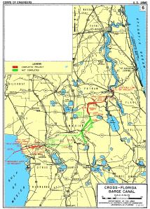
 Green on map indicates area not completed. Red on map indicates completed project.
About 28% of the 107-mile project was built—the cross-country section from the St. Johns River to the Oklawaha River, part of the route along the Oklawaha, and a small section at the Gulf of Mexico end up to the dammed Lake Rousseau.

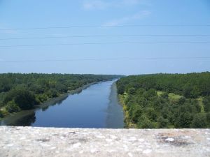
Photo on right:
One of the two completed sections of the Barge Canal, looking west from the SR 19 bridge south of Palatka.
The idea of such a canal was first proposed by Philip II of Spain in 1567. It was repeatedly considered over the years but found to be economically unviable. Secretary of War John C. Calhoun once again proposed a canal in 1818 in order to solve the losses due to shipwrecks and piracy. The Florida Railroad, finished on March 1, 1861, served a similar purpose, connecting the Atlantic Ocean at Fernandina to the Gulf of Mexico at Cedar Key.
In the 1930s, regional politicians lobbied the federal government to fund canal construction as an economic recovery program, and president Franklin D. Roosevelt allocated emergency funds in 1935. Local opponents of the canal protested that the canal would deplete Florida’s aquifers, and work was stopped a year later.
Work was reauthorized in 1942 as a national defense project, with dams and locks to protect the underground water supply. Support for the project from Washington was sporadic, and funds were never allocated to USACE to actually start construction.
Planning was once again given the go-ahead in 1963 with support from president John F. Kennedy, who allocated one million dollars to the project. The next year, Lyndon Johnson set off the explosives that started construction. It was hoped that the canal, along with the St. Johns-Indian River Barge Canal, would provide a quicker and safer route across Florida by 1971.
Opponents subsequently campaigned against the canal on environmental grounds, and the project stopped again in January 1971. It was officially cancelled in 1991. The right-of-way was turned over to the state and became the Marjorie Harris Carr Cross Florida Greenway, named in honor of the woman who led opposition to the canal. Carr had died the prior year, age 82.
Go here to read the full story:
http://en.wikipedia.org/wiki/Cross_Florida_Barge_Canal
This is also where Ocala Waterway got it’s name. Wow! How different things would be if this hugh barge canal ran through our beautiful county. Thank you Marjorie Harris Carr for standing up for what you thought was right in the face of what seemed to be an impossibility.
Looking to buy or sell…. I can help!
Teresa Fikaris, Buyer’s Agent (REALTOR) Cell: 352-208-5874
Fontana Realty
www.OcalaBuyersAgent.com

Actually there are 4 structures in the median, 2 tall and 2 short as well as a synopsis of what would have been on an information board beside the first tall structure for anyone to read, public tourist attraction spot for Santos. Currently in Google Sketchup I am working on a .. what if model of what that section of Marion county would have looked like.
Hi Travis,
Thanks so much for your comment regarding the Barge Structures. I am very interested in knowing more about your project, and would love to speak with you. Please feel free to give me a call at 208-5874 or kindly reply to this message. I will try to see if I can find what you are referring to on Google Sketchup. I’m not sure what that is, but I’d sure like to know more. Thanks again for your comment…. and I hope to have the opportunity to further discuss. Any information about our lovely area excites me! Oh by the way, after writing the Blog, I did notice that there were four structures (not 3) in the median.
Hi it’s me again, Google Sketchup is a program to make 3D models of almost anything and I am taking aerial photography from google maps and making a 3D version of the Santos/441 area into a What If … model if they had completed the canal. My first ever sighting of the structures was back when I was around 12 years old on a road trip to Disney World and has been in the back of my mind ever since. I moved down to Ocala in 2008 in the Belleview area and re kindled my interest in them and found out what they were finally. In time if progress of the Santos area model goes well I will render a full model of the entire canal and what the area might have looked like if it had been completed.
Hi Travis, Amazing that you responded today. My husband and I just took at day trip down Hwy 19 and looked at the part of the barge canal that was completed in Crystal River as we headed to Tarpon Spings…. Do you know any other information that you would like to share about the barge canal project? I’d love to speak with you, and if you ever get a chance, please feel free to give me a call. I mentioned to my husband regarding the Google Sketchup that you were talking about, and we were both very interested in knowing more…. thanks again for your response. Please keep in touch!
Hi again, a little more history on the canal today is about the Santos bridge supports. They were actually built in 1935 for back then was called the cross florida ship canal project and only 1 year into the work it was stopped. So by the time state road 316 and hwy 40 bridges were under construction, the Santos supports were already over 30 years old. If you can send me an email I will send a few pictures of the 3d model under construction and more story behind the area and canal I know of.
Hello Travis,
Pardon my interruption in your conversation but I’m also interested in seeing any 3D model of “what could have been”. I recently became aware of the CFBC on a return drive from Disney as we drove over the bridge on 19 North, and I’ve been googling it ever since. I grew up in Jacksonville and any old Florida history fascinates me.
Good luck on your project – I’d be happy to beta test it for you.
Thank you Derrick for your input… you are welcome to interrupt any time you like. Hopefully Travis will respond to your post and we all can learn from each other.
Hi Derrick and Travis,
Check out the photos that I posted on my Facebook page. The photos were taken by Charles Rinehart. He finallaly found the supports and he so graciously gave me permision to post them. If you cannot view them on Facebook, then let me know and I will email them to you.
Here is the link to my Facebook page:
http://www.facebook.com/pages/Ocala-Buyers-Agent/277718705606428#!/media/set/?set=a.506303226081307.122860.277718705606428&type=1
Hi again, been offline a few days but still working on the model, I have a current model so far I sent an image to you and you may add it here if you like. I will work more on the bridge any chance I get and will send updated pictures when completed. My next move is to buy a copy of “Ditch Of Dreams” and read even more into the history of the canal. It is the up to date most complete writing for the entire project covered with many archive photos as well. As for Beta testing, well I did plan to import the model into 3d Rad, a 3d game engine, and make a driving sim of the bridge when finished but that will be a little while down the road when I can complete more of the terrain in a recognizable fashion.
Pingback: “What If” the Cross Florida Barge Canal came through Ocala | ocalabuyersagent